







Iran’s space program can recover from war damage, says space research chief
Indigenous expertise remains industry’s main asset
By Sadeq Dehqan
Staff writer
Iran’s space research chief says the country’s space program can recover from wartime damage because its greatest asset is the expertise of its specialists. Missiles can destroy buildings and disable equipment, he says, but they cannot erase the knowledge embedded in scientists’ minds.
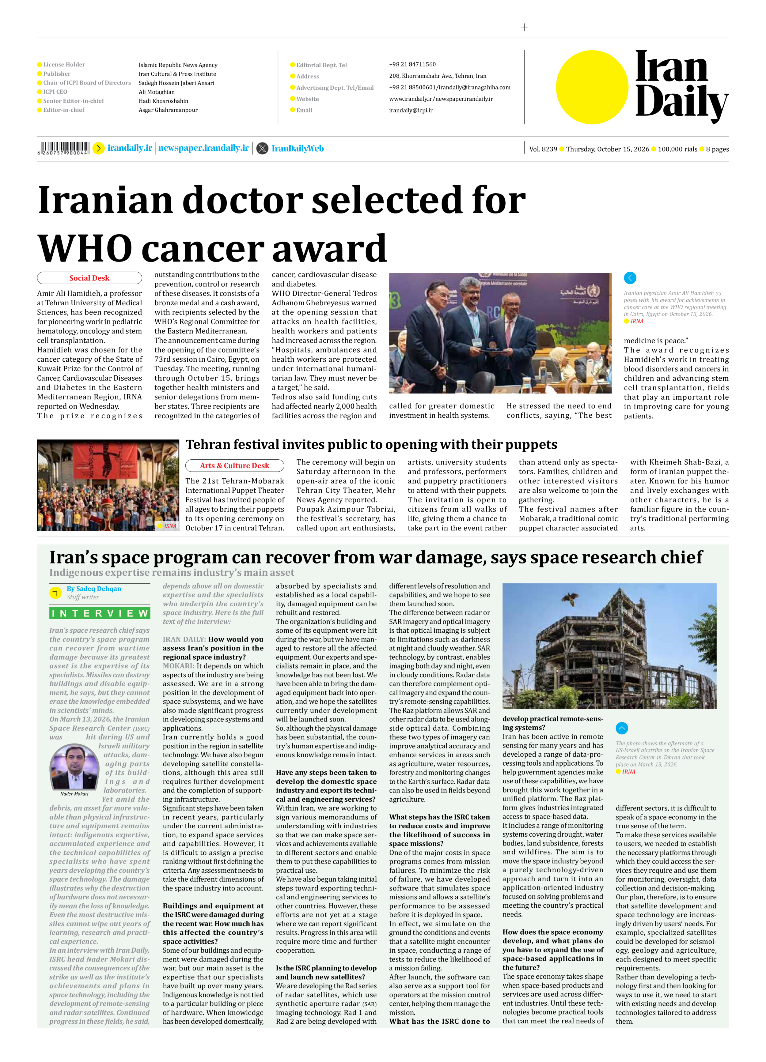
On March 13, 2026, the Iranian Space Research Center (ISRC) was hit during US and Israeli military attacks, damaging parts of its buildings and laboratories.
Yet amid the debris, an asset far more valuable than physical infrastructure and equipment remains intact: indigenous expertise, accumulated experience and the technical capabilities of specialists who have spent years developing the country’s space technology. The damage illustrates why the destruction of hardware does not necessarily mean the loss of knowledge. Even the most destructive missiles cannot wipe out years of learning, research and practical experience.
In an interview with Iran Daily, ISRC head Nader Mokari discussed the consequences of the strike as well as the institute’s achievements and plans in space technology, including the development of remote-sensing and radar satellites. Continued progress in these fields, he said, depends above all on domestic expertise and the specialists who underpin the country’s space industry. Here is the full text of the interview:
IRAN DAILY: How would you assess Iran’s position in the regional space industry?
MOKARI: It depends on which aspects of the industry are being assessed. We are in a strong position in the development of space subsystems, and we have also made significant progress in developing space systems and applications.
Iran currently holds a good position in the region in satellite technology. We have also begun developing satellite constellations, although this area still requires further development and the completion of supporting infrastructure.
Significant steps have been taken in recent years, particularly under the current administration, to expand space services and capabilities. However, it is difficult to assign a precise ranking without first defining the criteria. Any assessment needs to take the different dimensions of the space industry into account.
Buildings and equipment at the ISRC were damaged during the recent war. How much has this affected the country’s space activities?
Some of our buildings and equipment were damaged during the war, but our main asset is the expertise that our specialists have built up over many years. Indigenous knowledge is not tied to a particular building or piece of hardware. When knowledge has been developed domestically, absorbed by specialists and established as a local capability, damaged equipment can be rebuilt and restored.
The organization’s building and some of its equipment were hit during the war, but we have managed to restore all the affected equipment. Our experts and specialists remain in place, and the knowledge has not been lost. We have been able to bring the damaged equipment back into operation, and we hope the satellites currently under development will be launched soon.
So, although the physical damage has been substantial, the country’s human expertise and indigenous knowledge remain intact.
Have any steps been taken to develop the domestic space industry and export its technical and engineering services?
Within Iran, we are working to sign various memorandums of understanding with industries so that we can make space services and achievements available to different sectors and enable them to put these capabilities to practical use.
We have also begun taking initial steps toward exporting technical and engineering services to other countries. However, these efforts are not yet at a stage where we can report significant results. Progress in this area will require more time and further cooperation.
Is the ISRC planning to develop and launch new satellites?
We are developing the Rad series of radar satellites, which use synthetic aperture radar (SAR) imaging technology. Rad 1 and Rad 2 are being developed with different levels of resolution and capabilities, and we hope to see them launched soon.
The difference between radar or SAR imagery and optical imagery is that optical imaging is subject to limitations such as darkness at night and cloudy weather. SAR technology, by contrast, enables imaging both day and night, even in cloudy conditions. Radar data can therefore complement optical imagery and expand the country’s remote-sensing capabilities.
The Raz platform allows SAR and other radar data to be used alongside optical data. Combining these two types of imagery can improve analytical accuracy and enhance services in areas such as agriculture, water resources, forestry and monitoring changes to the Earth’s surface. Radar data can also be used in fields beyond agriculture.
What steps has the ISRC taken to reduce costs and improve the likelihood of success in space missions?
One of the major costs in space programs comes from mission failures. To minimize the risk of failure, we have developed software that simulates space missions and allows a satellite’s performance to be assessed before it is deployed in space.
In effect, we simulate on the ground the conditions and events that a satellite might encounter in space, conducting a range of tests to reduce the likelihood of a mission failing.
After launch, the software can also serve as a support tool for operators at the mission control center, helping them manage the mission.
What has the ISRC done to develop practical remote-sensing systems?
Iran has been active in remote sensing for many years and has developed a range of data-processing tools and applications. To help government agencies make use of these capabilities, we have brought this work together in a unified platform. The Raz platform gives industries integrated access to space-based data.
It includes a range of monitoring systems covering drought, water bodies, land subsidence, forests and wildfires. The aim is to move the space industry beyond a purely technology-driven approach and turn it into an application-oriented industry focused on solving problems and meeting the country’s practical needs.
How does the space economy develop, and what plans do you have to expand the use of space-based applications in the future?
The space economy takes shape when space-based products and services are used across different industries. Until these technologies become practical tools that can meet the real needs of different sectors, it is difficult to speak of a space economy in the true sense of the term.
To make these services available to users, we needed to establish the necessary platforms through which they could access the services they require and use them for monitoring, oversight, data collection and decision-making.
Our plan, therefore, is to ensure that satellite development and space technology are increasingly driven by users’ needs. For example, specialized satellites could be developed for seismology, geology and agriculture, each designed to meet specific requirements.
Rather than developing a technology first and then looking for ways to use it, we need to start with existing needs and develop technologies tailored to address them.