


Qeshm Geopark connects scientific research with tourism growth
Today, the concept of geoparks is a primary approach to tourism development in many advanced countries as well as in countries with limited natural resources or those whose industries and related production sectors are weak.
Geoparks are managed areas that include geological sites and natural, social, cultural, and historical resources, incorporating three key principles: conservation and sustainable utilization of Earth’s resources, education, and sustainable economic development. These three principles are also considered essential pillars in the definition of geoparks as important frameworks in land management, IRNA wrote.
Utilizing the natural capacity and geological heritage of underdeveloped and deprived areas, especially villages and less industrialized towns, to alleviate deprivation, create development incentives, and achieve the goals outlined in the country’s 20-year vision document, is among the main objectives of geoparks. Paying attention to this matter is highly important in land use planning discussions.
Moreover, by diversifying tourism activities in deprived and less developed regions, it is possible to create employment opportunities, reduce poverty, and establish relative welfare in these small population centers.
A revision of tourism policies by planners and decision-makers to invigorate tourism and attract tourists with diverse goals and interests to the country is a key point connecting land use planning and the geopark concept.
Designating an area as a geopark is a key strategy for reducing regional and territorial imbalances and achieving its comprehensive development. It is an essential and unavoidable necessity as one of the fundamental pillars of land use planning aimed at mitigating inequalities between villages, deprived areas, and cities in terms of opportunities, resources, and benefits.
Sustainable development goals
Balancing population distribution and activities in accordance with environmental capacity and various natural and divine resources at the regional level, enhancing the role of nature-based tourism in the national economy through utilization of the country’s natural, historical, and cultural heritage capacities, creating economic balance between deprived areas and metropolitan cities, and the principled and optimal conservation and use of capital, natural resources, and wealth in low-income and less industrialized regions, as well as developing regional geotourism — all contribute to outcomes of establishing a geopark within a territory and organizing the space for optimal utilization under the framework of national interests. The result is sustainable development and the creation of social, economic, and cultural welfare.
Therefore, it can be said that a geopark, by making optimal use of a region’s natural capabilities and environmental potential, serves as a complementary strategy for regional development. It can be considered a reliable step toward the advancement and development of rural areas and local communities across all economic, social, cultural, and environmental dimensions.
A pioneer in Iran
Qeshm Geopark is one of the earliest geoparks registered under the UNESCO Global Geoparks Network, established in 2006 with an area of approximately 300 square kilometers in part of Qeshm Island. Today, this geopark covers the entirety of Qeshm and Hengam islands, spanning an area of 2,063 square kilometers, making it one of the largest geoparks in the world.
Within this global geopark, diverse geological, natural, and cultural attractions are utilized for tourism as well as scientific and educational purposes through various designated geosites. These geosites are actively protected according to the conservation strategies and management of Qeshm Geopark.
The distance from Qeshm city to Bandar Abbas is 22 kilometers, and the shortest distance between Qeshm Island and the mainland is 1,800 meters.
Qeshm Geopark is the first in the country where special attention is given to the preservation of natural geological and cultural heritage through the cooperation and participation of the local community.
Within this geopark, various interpretive and explanatory tools are used to introduce geological phenomena and processes to tourists while promoting and developing the local economy through geotourism.
Major geosites
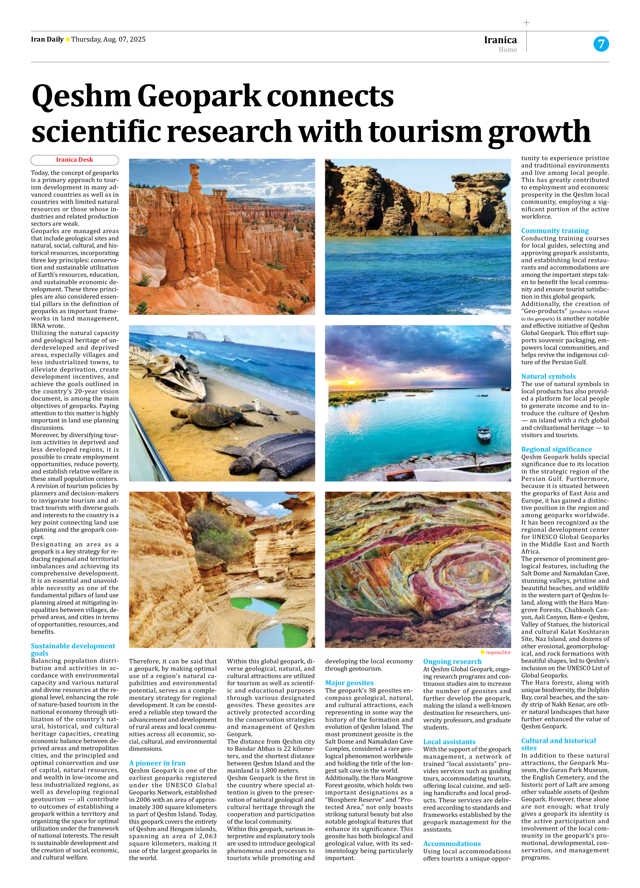
The geopark’s 38 geosites encompass geological, natural, and cultural attractions, each representing in some way the history of the formation and evolution of Qeshm Island. The most prominent geosite is the Salt Dome and Namakdan Cave Complex, considered a rare geological phenomenon worldwide and holding the title of the longest salt cave in the world.
Additionally, the Hara Mangrove Forest geosite, which holds two important designations as a “Biosphere Reserve” and “Protected Area,” not only boasts striking natural beauty but also notable geological features that enhance its significance. This geosite has both biological and geological value, with its sedimentology being particularly important.
Ongoing research
At Qeshm Global Geopark, ongoing research programs and continuous studies aim to increase the number of geosites and further develop the geopark, making the island a well-known destination for researchers, university professors, and graduate students.
Local assistants
With the support of the geopark management, a network of trained “local assistants” provides services such as guiding tours, accommodating tourists, offering local cuisine, and selling handicrafts and local products. These services are delivered according to standards and frameworks established by the geopark management for the assistants.
Accommodations
Using local accommodations offers tourists a unique opportunity to experience pristine and traditional environments and live among local people. This has greatly contributed to employment and economic prosperity in the Qeshm local community, employing a significant portion of the active workforce.
Community training
Conducting training courses for local guides, selecting and approving geopark assistants, and establishing local restaurants and accommodations are among the important steps taken to benefit the local community and ensure tourist satisfaction in this global geopark.
Additionally, the creation of “Geo-products” (products related to the geopark) is another notable and effective initiative of Qeshm Global Geopark. This effort supports souvenir packaging, empowers local communities, and helps revive the indigenous culture of the Persian Gulf.
Natural symbols
The use of natural symbols in local products has also provided a platform for local people to generate income and to introduce the culture of Qeshm — an island with a rich global and civilizational heritage — to visitors and tourists.
Regional significance
Qeshm Geopark holds special significance due to its location in the strategic region of the Persian Gulf. Furthermore, because it is situated between the geoparks of East Asia and Europe, it has gained a distinctive position in the region and among geoparks worldwide. It has been recognized as the regional development center for UNESCO Global Geoparks in the Middle East and North Africa.
The presence of prominent geological features, including the Salt Dome and Namakdan Cave, stunning valleys, pristine and beautiful beaches, and wildlife in the western part of Qeshm Island, along with the Hara Mangrove Forests, Chahkooh Canyon, Aali Canyon, Bam-e Qeshm, Valley of Statues, the historical and cultural Kalat Koshtaran Site, Naz Island, and dozens of other erosional, geomorphological, and rock formations with beautiful shapes, led to Qeshm’s inclusion on the UNESCO List of Global Geoparks.
The Hara forests, along with unique biodiversity, the Dolphin Bay, coral beaches, and the sandy strip of Nakh Kenar, are other natural landscapes that have further enhanced the value of Qeshm Geopark.
Cultural and historical sites
In addition to these natural attractions, the Geopark Museum, the Guran Park Museum, the English Cemetery, and the historic port of Laft are among other valuable assets of Qeshm Geopark. However, these alone are not enough; what truly gives a geopark its identity is the active participation and involvement of the local community in the geopark’s promotional, developmental, conservation, and management programs.